Written by Travis Knight // Photography by Camila Pereira
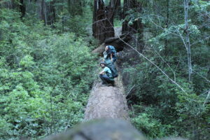
We did NOT wake up early. By the time we woke up, scarfed down our breakfast and coffee, cleaned our cookware, and packed up camp, it was well over noon. With daylight now illuminating our camp, it was now apparent that Milla and I were the only inhabitants of Waterman Gap Camp. I felt a touch of skepticism as to how this could be, but it was already too late to ponder such things. We desperately needed to hit the trail.
By now, I finally accepted that we would not be making it to the end of the trail. At this point, I was skeptical about even making it to Big Basin—now 8 miles away. Nevertheless, waking up in the middle of the forest and packing our small portable home—although clunky and huge for experienced backpackers—away in a pack and trekking forward on foot was beyond rewarding. For us, it was an experience that neither of us had ever encountered; one of both liberation and connection.
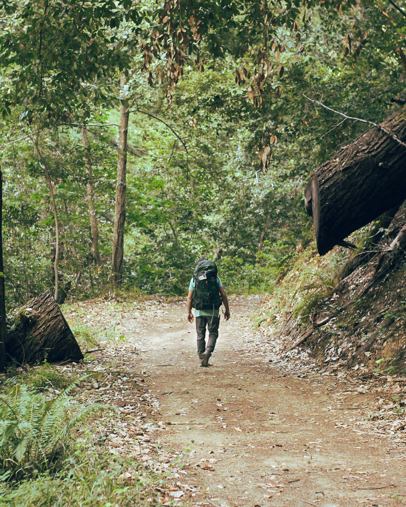
With packs back on, we sluggishly dragged ourselves onto the trail. My legs were sore and stiff, and Milla voiced that hers were, too. She was also experiencing strain in her back—a consequence of overpacking that we both were feeling—and she complained that her feet were beginning to hurt. I felt a tinge of annoyance when she complained about her feet, and the child in me wanted to blurt out “I told you so!” I mean, I had explicitly told her that a new pair of hiking shoes were likely crucial, and she had scoffed at me. Now she was surely kicking herself in the ass, so I thought it best to keep my childish thoughts to myself. Soon the silly “I told you so” turned into worry. How were we going to make it 8 miles if her feet were already in pain? We had not even been walking for 5 minutes. This was not good. But I ignored my spiraling thoughts and pushed on through the pessimism.
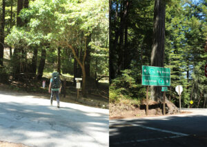
We winded our way up a steep trail. At the top, we found ourselves crossing the junction where Highway 9 and Highway 236 meet. A large green highway sign with a curious redwood seated behind it confirmed our whereabouts. The steep trek up had been miserable at first. But like a cold engine heating up on a brittle morning, our muscles likewise warmed up, and the walking became less painful. Milla also said her foot pain eased up. This news eased my nervousness. We crossed the road where Highway 9 and State Route 236 met, and continued onto the trail.
Now there were redwoods everywhere, families of the giants speckled all over the passing hillsides. A sign scolded us to not drop food—even crumbs—because it endangered a small sea bird called the Marble Murrelet. The sign did not explore why crumbs of any kind endangered these already endangered birds, and curiosity claimed our interest. And there I was, standing in a magical forest, Googling “Marbled Murrelet.”
The Marbled Murrelet is a seabird with a small beak and black and white feathers. At first glance, I cannot help but see a strange hybrid of a coot and a penguin. Although they spend their life at sea, Marbled Murrelets nest in Pacific old-growth forests, high up in the canopies of towering trees like the Coastal Redwoods. Aside from the deforestation of their habitat, Murrelets face another dilemma regarding their chances of survival. Beautiful forests, especially during a pandemic, draw in a lot of hikers. Irresponsible hikers or tourists drop food on the ground which lures larger birds like Ravens or Jays into areas where they would not normally reside.
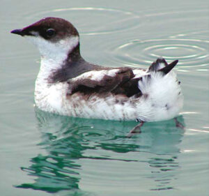
Once a Jay or Raven is attracted by a small seed someone dropped from their overpriced trail mix bag, the predatory bird searches for its next meal, which turns out to be the eggs or young of Marbled Murrelets. On the Pacific Coast, the sea-dwelling bird makes its long journey from the ocean and finds its home hundreds of feet in the branches of old-growth trees. The dilemma is that Marbled Murrelets only lay one egg at a time, which is nursed by two parents. A huge Jaybird or Raven swooping in is enough to scare the parents away from their nest, which gives these opportunistic birds an easy meal. In short, we humans have once again fucked up an entire ecosystem.
Milla and I were fascinated with how delicate this ecosystem was. Before, if we had dropped a biodegradable crumb like a seed or grain of granola in a forest, we likely would not think much of it. This new information, though, made us tread more carefully when we pulled out a snack. Now I felt like a dick for even washing our cookware back at camp without burying the small leftover food parcels. But hey… we live and learn.
The hiking for both of us got a bit easier as our muscles softened through the strain of hiking. Instead of switch-backing up a mountain, we were switch-backing along a mountain. All the while cars zoomed past Highway 9 just below–which was kind of annoying, seeing that we were supposed to be in the backcountry. “Switch-back trails” refer to trails that weave right to left, slowly crawling up a steep mountain and avoiding the arduous steps that it takes to go up the same mountain when walking up a vertical straight trail. When I think of switchbacks, I think of a swimming water snake, frozen in time on the side of a mountain. The weather was perfect, with a chilly coastal breeze interrupting the heavy summer heat that would make its way through the draping canopies above.
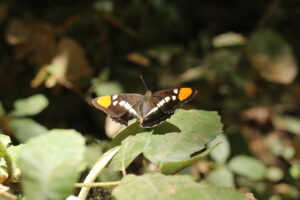
Every now and again, a fluttering flash of color would grab our attention. Most of our encounters with these flapping beings would be short-lived. They would lightly kiss our vision only to swiftly disappear into the surrounding foliage of ferns and other small shrubs. However, if we got lucky, the little butterflies would land on a sunlit leaf and take a moment to bathe in rays and show off their shimmering black wings, symmetrically equipped with patches of pumpkin orange, blood red, and brilliant whites. Observing the little idling butterfly, we froze with fascination.
The butterfly, known as the California Sister, flaps its wings through a large portion of California, Southern Oregon, and parts of Nevada. People commonly mistake it for another butterfly that frequents Northern California, Lorquin’s Admiral. Both butterflies wear the same color combo, however, they slightly differ in their pattern. The difference occurs in the bright autumn orange that each insect sports. The California Sister’s orange is more of a circular splotch located at the tip of its wings, while the Lorquin’s Admiral’s orange slivers along the upper tip of the wings, taking up most of the top wings’ edges. Furthermore, the Sister’s wings grow much larger—nearly twice the size—than the Lorquin’s Admiral.
As the day sunk into late afternoon, the sun did the opposite, ruthlessly rising and draping salty sweat into our eyes. Highway 9 was long gone, and now we were climbing higher into a landscape that was more like Castle Rock than the Redwood forests we had just trekked. The terrain offered less shade, and to top things off, we were running low on drinking water. Milla was now nearly limping along because her feet were so torn up. The heat and weight on my back were pulling at my nerves, and instead of feeling bad for my suffering wife, I secretly resented her for slowing us down—all because she wanted to save a few bucks on shoes. I knew I was being an asshole, but every time I got far ahead of her, I found myself cursing her under my breath as she caught up. At this pace, we would be lucky to make it to Big Basin by nightfall. To make matters even worse, both of our phones had no reception, and my dad was planning to rendezvous at Big Basin around 4 p.m. It was now 3:45, we still had at least 4 miles to go, and yes, we were officially out of water.
Our parched throats and throbbing feet were screaming at us to stop. But if we stopped, then we would be one step further from water. An unnamed, blue line on our map lifted our hopes with the promise of water. However, we would find out that this promise was empty, and yet another backpacking growing pain was tossed on top of the now augmenting pile of fuckups. Now I was cursing myself for relying on a creek that our map showed ran through the trail. When it comes to streams, never rely on a map for water.
“… and yes, we were officially out of water.”
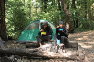
We would have to suffer another two miles before we found water. But when we found it, our anger melted away. Smiles stretched our weary cheeks, and by now, we were even laughing. The first sign of the water was nonmoving in still-sitting pools. We followed the pools of water, and as we went upstream, the stream gained momentum. Finally, a rushing stream sat flowing in front of our eyes. With bellies full of water, our water bag filled to the brim, and our cooking pot full of boiling bubbles, life was good. We even forgot about what time it was.
With grateful stomachs now full, it was time to put aside our weariness and get back on the trail. At this rate, we would not be stepping into Big Basin until after sundown. It was Sunday, and both of us had to be back at work early that Monday, so straying another night in the wilderness was not an option. Milla and I knew we had to push past the pain if we were going to make it out that day.
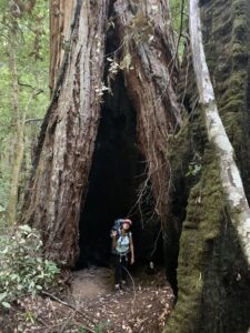
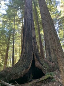
It was 5:30 pm when we finally started seeing the signs for Big Basin. We had made it, and in good time, too—although we still did not know how far we were from the parking lot, which was the rendezvous spot for getting picked up. Deep down, I finally let go of the pressure in my chest, pressed by time and the dwindling sunlight. Instead, I just enjoyed the surroundings. Gargantuan coastal redwoods now surrounded us, with vibrant, sprawling ferns at their feet. Fallen trees granted a close-up view of how big these trees really were. Being next to a living thing–or once-living thing–that large will tend to humble oneself.
As I mentioned in part one of this story, Big Basin is “the oldest state park in California,” and at the center of this formation lie early conservation efforts. Due to the climbing rate of sawmills back in 1900, a revolutionary of conservation, Andrew P. Mill–with the help of other like-minded colleagues–gave birth to the Sempervirens Club. It would take two years of dedicated work for the organization to persuade California legislation to salvage nearly 4,000 acres of old-growth forest. The freshly formed state park, however, would not be available to visitors until 1904.
Just under 12 decades later, Milla and I found ourselves enjoying the result of those early conservation visionaries. We stood in awe as these enormous redwoods hypnotized us. Our imaginations had trouble wrapping their fingers around the beauty and size of these ancient giants. Some of them were hollowed out, and so large that it was quite possible to fit a small vehicle in the trees’ arched cavities. Among the throngs of coastal redwood families, the forest vibrated with Douglas Fir, Tan Oak trees, Huckleberry bushes, and sprightly ferns.
As a photographer, Milla was in heaven, capturing everything the eye could see with the clicking of her camera. I, too, was dumbfounded by what my senses were relaying to my brain. The river around us glowed with a green tint, while natural bridges of fallen trees connected one side of the riverbank to the other. By now, the sun was really dwindling, a bittersweet happening. Bitter because it was getting so late. Sweet because it was Golden Hour in the forest. Sadly, though, we had no time to explore the park. We needed to be in the parking lot two hours ago, and we still were not sure how far the parking lot was.
Although we had not made it to the sea part of this long trail, we had hiked roughly 17 miles to arrive at Big Basin State Park. Later that evening, while devouring victory sandwiches in Boulder Creek, my dad would tell us that one of the park rangers yelled at him when he asked them if two backpackers with our description had arrived at the park yet. After an hour of waiting and not hearing from us, he had begun to worry, so he asked a young woman with ranger clothes on if anyone working at the park had seen us. At first, she seemed confused, so he told her that we had camped at Waterman Gap the previous evening—information I had shared with him within the small sliver of phone reception we had gotten earlier that day.
“No, we have not seen them,” the ranger said, “But when we do, they’re gonna be in a lot of trouble. Due to COVID-19, the trail AND the campsite are closed to the public. And if it wasn’t closed, they would need permits! How did they get out there, anyway?” This response explained why my father was so quick to get us in the car once he saw us drag our feet into the parking lot. Apparently, Milla and I had obliviously walked by the main ranger headquarters in Castle Rock and were undetected. I also somehow missed the fact that “The Skyline to the Sea Trail” was closed. Honestly, until that day, I thought “backcountry” meant “go for it” and “it’s free!”
Just two weeks later, lightning would ignite “the 86,509-acre CZU Complex Fire,” which would devastate Big Basin State Park. This fire was far from the first rodeo for many of the humongous coastal redwoods. However, the fire would shut down the park to the public for two years. Milla and I had no idea that the immense beauty we witnessed that day would go up in smoke merely weeks after.
For most of us—if not all of us—the year 2020 was fucked. Domestic violence was not the only shitshow on the rise. The US News & World Report found that mental health problems in adults “rose from 19.2% in 2019 to 20.3% in 2020,” affecting more than 3,295,000 Americans. Alcohol-related deaths “rose nearly 30% in the U.S.” in 2020 and opioid-related deaths—both from illicit and over-the-counter prescriptions—rose by 21,169 from 2019. From opioid addiction alone, a total of 91,799 Americans lost their lives in 2020, nearly double when compared to 2015.
Milla and I felt like we found a cure for the felt devastation in 2020. By putting on our packs and pushing the limits of our bodies, we came out of the experience with a rewarding combination of exhaustion and vigor. Aside from a few miles here and there when highway 9 slithered alongside us, we were surrounded by nothing but the natural world for nearly 48 hours. We had found a way to sidestep the whirlwind of suffering that the COVID-19 pandemic brought. We found liberation amidst lockdowns—health amidst sickness—peace amidst panic. When it came to backcountry trekking, one thing became certain: we were hooked.